
CHAIRMAN’S FOREWORD

Significant spatial projects were reaching critical milestones as I took the role of chairman of ICSM. In particular this involved the ANZLIC driven Foundation Spatial Data Framework (FSDF) and the Australian Datum Modernisation projects. From an ICSM perspective, these projects had been matured through the inspirational leadership of Mr Paul Harcombe, my predecessor who deserves the gratitude of all of the ICSM member organisations for the legacy of his work. Mr Michael Burdett, Surveyor-General of South Australia
Because of the breadth and significance of the FSDF project, for which ICSM agreed to accept a sponsorship role for seven of the ten themes, ICSM commenced this period with a major workshop aimed at both setting the strategic direction for ICSM and agreeing the key work programs of the FSDF leading to the development of a three year roadmap for each of the data themes.
Three key milestones were reached during my term as chairman. The first was the maturing of the FSDF through the development of the “registry” concept ( later to become “theLINK”) as an innovative way mapping, managing and reporting on the key spatial datasets of Australia. Further it aimed to provide a real understanding of the provenance of, and delivery of benefits by this data.
The second was in May 2015 where both ICSM and ANZLIC endorsed the update of the Australian Geodetic Datum to GDA2020. This was the culmination of many years of work by all of the states and territories in the development of the datum. Underpinned by academic research through the CRCSI and through the hard work of dozens of dedicated practitioners this technical work, ably led by the Permanent Committee on Geodesy has been shown to be truly world leading. The next challenging phase of implementing the datum was commenced through the establishment of the implementation committee, a move from the technical phase to one of communication.
And thirdly, the publication of the forward looking strategy for Land and Real Property — Cadastre 2034 was released at the Locate 2015 conference. This work sets out the challenges for the industry in the coming years in ensuring the governance and technical framework around our cadastre remain relevant and serve the changing needs of our community. ICSM promoted this strategy document widely following its release including presentations at international forums.
Beyond these projects of significance there have been many other pieces of work undertaken by the ICSM working groups, mostly guided through the program of works identified in the FSDF roadmaps. It includes the preparation of a baseline report for the status of jurisdictional spatial datasets by SIDA, the development and publishing of the standard for control networks, SP1, the consolidation of the State Borders dataset, support for the implementation of ePlan into our cadastral systems, updating the Australian Tides Manual SP9, determining the linkage between tidal reference levels and AHD , the development of consistent feature type classification, the compilation of surface water catchment data, the accurate mapping of the Australian coastline and protection of historic aerial imagery.
Communication has been a strong focus for ICSM. Being a committee of ANZLIC the strong ties have been maintained through our reporting at the ANZLIC meetings and through representation in the FSDF Program Management Office. Through a new initiative of opening up our meetings to industry representatives sound relationships have been reinforced with the spatial community. Relationships with Standards Australia and PSMA have been maintained, ones which are critical to the work of ICSM and ICSM was pleased to accept a position on the National Positioning Infrastructure advisory board.
ICSM have partnered with the academic sector, jointly benefiting through research into areas such as datum modernisation, property addressing and the 3D cadastre. This research is targeted at providing technical application to many of the core functions overseen by ICSM.
ICSM has also been represented in the international arena. The ePlan working group has developed close ties with our Singaporean counterparts. Mr William Watt is currently chairing the United Nations Group of Experts on Geographical Names (UNGEGN) and Mr Gary Johnston chairs the International GNSS Services (IGS) Governing Board. Through these appointments, Australia is making a significant international contribution.
I have found the role of Chairman a rewarding one, giving me the opportunity to work with many exciting colleagues from the spatial sector. The work of ICSM generates long term benefits to the Australian and New Zealand community through the work of many people. At a personal level I would like to thank them for their contributions. I would also like to recognise the relationship between Australia and New Zealand and the reward and value each country is able to bring to ICSM. Many thanks go to the ICSM Executive Office, Lesley Waterhouse for the tireless organisation of a group widely spread across our nations.
Finally, with great confidence I hand over the chairmanship of ICSM to Michael Giudici with whom I very much look forward to working with through his term in office.
Michael Burdett, Chair
1 July 2014 – 30 June 2016
Achievements During 2014–2016
- Development of Foundation Spatial Data Framework (FSDF) Registry of datasets from across the nation
- ICSM continued its role being sponsor of seven FSDF themes and to have a major contributing role in the other three themes by participating in the Project Management Committee
- ICSM participation in the National Positioning Infrastructure (NPI) Advisory Board and workshops
- Endorsement by ICSM and ANZLIC to update the Australian Geodetic Datum to GDA2020
- Major progress of the datum modernisation project, and the GDA Modernisation Implementation Working Group (GMIWG) established in Oct 2015 to complete this work
- GeodesyML V03 released on a new website www.geodesyml.org
- Launch at Locate15 of the final version of the national cadastre strategy, Cadastre 2034
- Completion of baseline report for the status of jurisdictional spatial datasets by SIDA working group, which formed the basis of the FSDF Registry
- Completion of FSDF road maps
- Publication of new version of the Standard for the Australian Survey Control Network (SP1)
- GDA94 Technical manual updated to V 2.4 in December 2014
- Consolidation of State borders dataset
- Update to Australian Tides Manual (SP9)
- Accurate mapping of the Australian coastline
- Determining linkage between tidal reference levels and the Australia Height Datum (AHD)
- Following the success of Regulation 13 weeks held in 2013 and 2014, a national GNSS CORS Regulation 13 certification campaign has become an annual event
- Protection of historic aerial imagery.
COLLABORATIVE INITIATIVES
- Collaboration with Melbourne University and other partners of 3D Property Ownership Map Base for Smart Urban Land Administration.
- Collaboration with CRCSI on GDA2020 research
- Joint meetings of PCC with CRSBANZ to achieve the goals set out in Cadastre2034
- Commencement of work with GA, Curtin Uni, LPI, LINZ, Landgate & CRCSI on new national geoid model.
About ICSM
Our vision
National land and marine spatial infrastructure providing sustainable benefits for Australians and New Zealanders
Our role
To provide leadership, coordination and standards for surveying, mapping/charting and foundational spatial data.
Who we are:
The Intergovernmental Committee on Surveying and Mapping (ICSM) is a standing committee of ANZLIC, the Spatial Information Council.
ICSM members represent 11 jurisdictions and are senior representatives of Australian and New Zealand commonwealth, state and territory surveying, mapping and hydrographic charting agencies.
ICSM is supported by a network of permanent committees and working groups. Working group members come from key government, academic, and private organisations from within Australia and New Zealand.
National
- Australia–civilian
- Australia–military (terrestrial and marine)
- New Zealand
Australian State/Territory
- Australian Capital Territory
- New South Wales
- Northern Territory
- Queensland
- South Australia
- Tasmania
- Victoria
- Western Australia
What we do:
As a key coordinating body in Australia and New Zealand for surveying and mapping issues, ICSM provides a forum that enables the exchange of information and ideas.
Our function is to:
- provide national coordination of surveying and mapping activities and research
- establish protocols and technical standards for spatial data and related infrastructure
- support the acquisition and maintenance of datasets forming the foundation data framework
- develop and publish best practice guidelines, national technical policies, standards, specifications and data models for foundation spatial data
- encourage a consistent approach across jurisdictions to spatial data policies, standards, programs and priorities
- provide technical advice and support to other coordinating bodies
- promote data integration
- provide a forum to share knowledge, experiences and expertise for foundation spatial data
- communicate and develop relationships with key stakeholders in government, industry and the user community.
How we add value:
ICSM’s activities support government and industry, and:
- provide national coordination, encouraging efficiency through consistency and cooperation, sharing best practice, and reducing duplication
- create enabling infrastructure (including products)
- support networking, learning and innovation across the surveying and spatial information sector
- increase advocacy for spatial information and surveying to improve efficiency and decision making.
How we work:
The ICSM Terms of Reference and Governance Charter is a set of rules that govern the conduct of our activities.
ICSM meets every six months and informs stakeholders of progress and activities through publications on our website and through email.
A Chair is appointed from the Committee every two years and an ICSM Executive Officer delivers secretariat and project support to members, Permanent Committees and working groups.
ICSM invites subject matter experts and key stakeholders to attend meetings to discuss items of mutual interest.
History
Prior to 1988, the National Mapping Council (NMC) coordinated Australian mapping programs. Although the NMC had been an effective forum, the changing operational environment required the formation of a national organisation to cover both surveying and mapping issues.
ICSM was established by the Prime Minister, State Premiers, and the Chief Minister of the Northern Territory in 1988. The Australian Capital Territory and New Zealand also joined ICSM.
In 2002 ICSM became a standing committee of ANZLIC—the Australian and New Zealand Spatial Information Council.
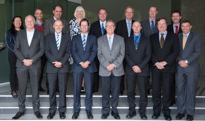
Delegates to the ICSM meeting in Hobart, October 2015
Back row, left to right:
- Zarina Jayaswal (AHS)
- Simon Costello (Aust)
- John Tulloch (Vic)
- Lesley Waterhouse (ICSM EO)
- Gary Johnston (Aust)
- Russell Priebbenow (Qld)
- Ron Jarman (ACT)
- Paul Duncan (WA)
Front row, left to right:
- Mark Dyer (NZ)
- Michael Burdett (SA and ICSM Chair)
- Michael Giudici (Tas and ICSM Deputy Chair)
- John Gallagher (Vic)
- Rohan Hill (AGO)
- Paul Harcombe (NSW)
- Craig Sandy (NT)
See the ICSM Membership section for information about individual ICSM agencies.
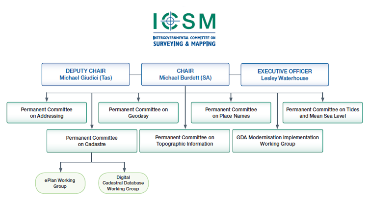
Permanent Committee on Addressing (PCA)
Sponsor, John Tulloch
Surveyor–General, Department of Sustainability & Environment
Victoria
About PCA
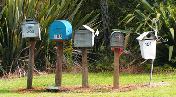
The Permanent Committee on Addressing (PCA) aims to provide leadership in addressing, road naming and locality definition. This includes setting standards, developing guidelines, and promoting systems for the efficient interchange and sharing of addressing data.
Activities During 2014–2016
- Development of a Work Program and Terms of Reference which align with the FSDF Geocoded Addressing theme goals, but with more focus on the quality of addressing
- Consolidation of earlier work on the PCA Addressing Guidelines that augment the AS⁄NZ addressing standard 4819
- Assessment of the NSW ‘Addressing User Manual’ (published in April 2015 and associated ‘Address Policy’ which identified that the documents do not include the material that PCA intends to include in its Addressing Guidelines, which remain a work in progress.
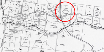
Permanent Committee on the Cadastre (PCC)
Chair, Richard Browne
Chief Inspecting Surveyor, Inspector of Plans and Surveys, Landgate Western Australia
Sponsor, Russell Priebbenow
Director, Cadastral and Geodetic Services, Director of Surveys
Land and Spatial Information Group
Department of Natural Resources and Mines, Queensland
About PCC
The Permanent Committee on the Cadastre (PCC) was established in 1999 to provide a leadership role in:
- advising ICSM on cadastral matters
- raising awareness of the cadastre and the benefits of the digital cadastral system to the spatial industry and the community.
Its role is to develop a coordinated approach to cadastral maintenance and improvement of digital cadastral data. This incorporates involvement with all stakeholders, including other peak government and industry groups.
Activities During 2014–2016
- The Cadastre2034 strategy was launched by Paul Harcombe at Locate15, which incorporated of many suggestions and feedback received during the consultation phase of the draft strategy.
- Joint meetings regularly held with CRSBANZ to assist in realising the goals set out in Cadastre2034.
- Further support of University of Melbourne with research into 3D cadastral information.
- Continued support on the Land Parcel and Property Theme of the Foundation Spatial Data Framework.
ePlan Working Group (ePlan)

Chair, Chris Wilcox
Manager, ePlan Project,
Land and Property Information Division NSW,
Department of Finance, Services & Innovation
Sponsor, Michael Giudici
Surveyor–General
Department of Primary Industries, Parks, Water and Environment, Tasmania
About e–Plan
This committee was established in November 2003 when it was recognised that a national cadastral data transfer standard was needed to capitalise on the inherent efficiencies that electronic lodgement and processing of digital cadastral data can bring.
The ePlan Working Group is composed of representatives from industry and government to review and progress this change. In late 2010 the ePlan group published the Australian ePlan Protocol and moved its focus from the Development of the Protocol to implementation within the Jurisdictions.
Activities during 2014–2016
- A Technical Working Group subcommittee was created and their tasks include investigation of building and strata subdivisions in ePlan. Dr Hamed Olfat (Land Victoria) is the chair of this group.
- The ePlan Terms of Reference updated to include the implementation of 3D cadastres, the maintenance of the protocol in line with 3D cadastres and aligning the Protocol with the Land Administration Data Model (LADM).
- Actively participating in OGC LandInfra development through various means. Chris Wilcox (Chairman ePlan WG) has become an active member of the OGC through the NSW LPI membership.
- An interactive 3D ePlan Prototype system was implemented by Land Victoria that illustrates how the legal and physical objects of a building subdivision plan can be stored, visualised and queried in a 3D digital system. As part of this study, the ICSM ePlan Protocol was evaluated in terms of supporting 3D building subdivisions. Further input from other states is required to complete 3D sections of the National Protocol.
- The Northern Territory no longer accepts “hard copy” plans as lodgements. They have progressed to 100% electronic lodgement including the lodgement of a geodatabase . The ACT and Tasmania have taken steps towards implementation of electronic workflows through various strategies and educational process throughout industry. Queensland accepted their first ePlan submission.
Permanent Committee on Geodesy (PCG)
Chair, John Dawson
Section Leader, Geodesy
Geoscience Australia
Sponsor, Gary Johnston
Group Leader, Geodesy and Seismic Monitoring Group
Geoscience Australia
About PCG
Geodesy provides the positional framework for all surveying, mapping and geographic information applications in Australia. The PCG is responsible for providing advice on geodetic issues. It has existed as a series of working groups since the inception of ICSM in 1988. The PCG’s primary role is to maintain a compatible geodetic infrastructure across Australia and New Zealand.
Activities During 2014–2016
Standard for the Australian Survey Control Network Special Publication No.1 (SP1)
An updated version of the Standard for the Australian Survey Control Network — Special Publication 1 (SP1), version 2.1 includes the RTK and NRTK positioning techniques.
GDA Technical Manual
The Geocentric Datum of Australia Technical Manual was updated to Version 2.4. In the eight years since the Technical Manual had been last updated, there have been changes to the Australia Fiducial Network (AFN) gazettal values as well as advances in AUSGeoid and the International Terrestrial Reference System and Frame. Revisions of the Technical Manual include updating the text to make explicit the non-equivalency of GDA94 and WGS84/ITRF and the correction of an error in a formula.
United Nations
Gary Johnston was elected as the Chair of the International GNSS Service (IGS) Governing Board.
The United Nations General Assembly adopted the first geospatial resolution. The Global Geodetic Reference Frame for Sustainable Development (GGRF) resolution outlines the value of geodetic infrastructure, observations and the impact they can have on decision making.
After the adoption of the UN GGRF resolution, the working group has commenced working on a Roadmap to build a framework to implement the Global Geodetic Reference Frame.
GeodesyML
GeodesyML V0.3 was released along with a new website, www.geodesyml.org. This follows acceptance of GeodesyML by the International GNSS Service (IGS) Governing Board as the XML based standard for encoding and transferring site log metadata.
Geocentric Datum of Australia Modernisation Implementation Working Group (GMIWG)
The Geocentric Datum of Australia Modernisation Implementation Working Group (GMIWG) was formed in October 2015. The Function of the GMIWG is to take responsibility for the practical aspects associated with the GDA Modernisation. The Committee is responsible for determining stakeholder requirements, defining the benefits of modernisation, monitoring risks, quality and timeliness of the implementation and determining and providing appropriate communication with all stakeholders.
Permanent Committee on Topographic Information (PCTI)
Chair, Graham Hammond
Section Leader, Physical Geography, Geoscience Australia
Sponsor, Simon Costello
Group Leader, National Location Information Group
Geoscience Australia
About PCTI
The aim of the Permanent Committee for Topographic Information is to enhance the coordination of Geographic Information Management and associated activities undertaken by the jurisdictional mapping agencies and the private sector.
Activities During 2014–2016
PCTI is ICSM’s main working group for activities in the FSDF Themes of Elevation & Depth, Water, Imagery, Transport and Land Cover road maps . It will also provide input into Place Names and Addressing activities, as well as supporting cross-theme activities.
PCTI represents many of the custodians of the 800+ inputs and national datasets making up the Foundation Spatial Data Framework.
Program progress is tracked through the FSDF Knowledge Base and various reports, showing different levels of details, are created every quarter ahead of the ANZLIC and ICSM meetings.
Queensland and New South Wales both expressed a desire to implement national approaches to foundation spatial data management and delivery. These are now being progressed as project proposals in the FSDF as demonstrators, to show all jurisdictions how changes to dataset quality, supply chain, accessibility and policy, can be applied locally within each jurisdiction but done in a nationally consistent manner. At this initial stage, the proposals will look at ingestion and delivery of state-based elevation and imagery datasets via national platforms, and improvements to the supply chain for the Gazetteer of Australia. It is likely that both State and Commonwealth resources will be devoted to this as part of work planning for the next couple of financial years.
There was recognition that the National Topographic Information Coordination Initiative (NTICI) framework continues to work well to allow jurisdictions to collaborate on many varied projects.
ICSM endorsed the formation of Aerial Photography Taskforce reporting directly to PCTI. The Taskforce conducted an audit of all jurisdictional aerial film digitisation capabilities, to establish where pockets of expertise exist, their capacity, baseline costs and identify any specific issues. This may include a private sector where there is an existing relationship as the preferred supplier, eg where equipment or technical expertise to scan aerial film no longer exists within custodian organisation. At the completion of the audit the Taskforce developed a draft holistic national dataset management plan for aerial photography.
Permanent Committee on Place Names (PCPN)

Chair, Danielle Stefani
Landgate, Western Australia
Sponsor, John E Tulloch
Surveyor–General of Victoria
Department of Sustainability & Environment, Victoria
About PCPN
Our role is to coordinate and communicate the consistent use of place names to ensure they meet the requirements of the whole community, including government bodies and emergency services; and also indigenous people.
Through PCPN, Australia and New Zealand participate in the activities of the United Nations Group of Experts on Geographical Names (UNGEGN) and contribute to world best practice in the management of place names.
Activities During 2014–2016
Mr Bill Watt continued his work as Chair of United Nations Group of Experts on Geographical Names (UNGEGN).
The Feature Code Working Group continued its efforts to finalise a feature code list that was provided to all jurisdictions for feedback. The aim is for all jurisdictions to adopt the same feature classification system or to adopt a process of ‘mapping’ the data upon extraction to enable the information to be provided to Geoscience Australia in a more usable format for the creation and distribution of the Australian Gazetteer.
Permanent Committee for Tides & Mean Sea Level (PCTMSL)

Chair and Sponsor, Commodore Brett Brace
Director General Navy, Hydrography and METOC
Hydrographer of Australia
About PCTMSL
The main role of the Permanent Committee for Tides and Mean Sea Level is to coordinate a national database of tidal records as well as develop national standards and best practice guidelines for tidal related matters. PCTSML also acts as a focal point for national inquiries relating to tides and mean sea level and identifies long-term tide and sea level management requirements for Australia and New Zealand.
Activities During 2014–2016
The Tidal Realm Model was included in the Foundation Data Spatial Framework (FDSF)’s Elevation & Depth Theme to provide a common reference for onshore and offshore elevation of Australia and New Zealand. PCTMSL has forwarded all information and data relating to the Tidal Realm Model to Geoscience Australia (GA) including details of the work it had carried out in respect of this project. Progress on the formulation of a plan to oversee its implementation in the FDSF is ongoing.
Financing Our Work
| 2015 | 2016 | |
|---|---|---|
| Receipts | $ | $ |
| Subscriptions | 91 800 | 78 850 |
| Bank Interest | 5 752 | 4 447 |
| GST Received | 8 260 | 6 955 |
| Third Party Contributions | 9 325 | 88 |
| GST refund | 11 649 | 1 246 |
| Total Receipts | $126 786 | $91 586 |
| Payments | $ | $ |
| PC Addressing | 175 | 0 |
| PC Cadastre | 36 262 | 4 556 |
| PC Geodesy | 25 447 | 28 563 |
| PC Place Names (PCPN) | 941 | 4 809 |
| PC Tides & Mean Sea Level | 33 | 598 |
| PC Topographic Information | 629 | 2 259 |
| SIDA | 18 154 | 77 |
| Other Projects | 33 743 | 5 000 |
| Executive | 12 546 | 10 030 |
| Stationery and Publications | 5 821 | 111 |
| Auditor’s and bank charges | 1 464 | 1 350 |
| GST paid | 17 996 | 11 803 |
| Total Payments | $153 211 | $69 156 |
The operating deficit for this period was drawn from reserves, part of which was used to engage external expertise to assist ICSM projects when necessary.
Activities and Events
As part of our policy of engaging with spatial professionals; over the two years covered by this report, ICSM has had a significant presence at the following events:
- Locate15 Conference - Brisbane, April 2014
- Locate16 Conference - Melbourne, April 2015
- United Nations Group of Experts on Geographic Names (UNGEGN) Congress
- United Nations Committee of Experts on Global Geographic Information Management (UNGGIM)
As part of our strategy of informing about our activities; we:
- release the Minutes of ICSM Meeting every 6 months
- publish our Biennial Report every 2 years
- publish the ICSM Newsletter every 6 months
- routinely publish general information material.
ICSM Members
Simon Costello
Group Leader,
National Geographic Information Group
Geoscience Australia
Gary Johnston
Group Leader,
Geodesy & Seismic Monitoring
Geoscience Australia
Commodore Brett Brace, RAN
Hydrographer of Australia
Australian Hydrographic Service
Rohan Hill
Assistant Director Data Management,
Australian Geospatial–Intelligence Organisation (AGO
Mark Dyer
Surveyor–General
Land Information New Zealand
Ron Jarman
Deputy Surveyor–General
Environment & Planning Directorate
Paul Harcombe
Deputy Surveyor–General of NSW
Land and Property Information
Craig Sandy
Director, Surveys
Department of Lands, Planning
& the Environment
Dr Russell Priebbenow
Director of Surveys
Spatial Information Group
Department of Natural Resources
and Mines
Michael Burdett
Surveyor–General
Land Boundaries,
Information & Strategy
Department of Planning, Transport
and Infrastructure
Michael Giudici
Surveyor–General
Land Tasmania
Department of Primary Industries,
Parks, Water & Environment
John E Tulloch
Surveyor–General of Victoria
Department of Environment, Land,
Water & Planning
John Gallagher
Manager
Spatial Information Infrastructure
Department of Environment, Land,
Water & Planning
Paul Duncan
Director
Location Knowledge Services
Landgate
Lesley Waterhouse
ICSM Executive Officer
Geoscience Australia
Email: icsm@ga.gov.au
Phone: (02) 6249 9677
Mobile: 0419 694 669
Australia–Civilian
Geoscience Australia
GPO Box 378
CANBERRA ACT 2601
![]()
Within the Commonwealth portfolio Resources, Energy and Tourism, Geoscience Australia takes a lead role in producing national geoscientific information and knowledge. Key areas of activity include data acquisition, analysis and dissemination, research and advice associated with:
- topographic mapping and data
- pre-competitive petroleum exploration
- pre-competitive onshore mineral exploration
- coastal zone and sea-bed mapping, including Australian Marine Spatial Information System (AMSIS)
- risk analysis and modelling to support national initiatives for Disaster Mitigation Australia, counter terrorism and critical infrastructure protection
- seismic and geodetic monitoring
- Australian National Tsunami Warning System (ATWS)
ICSM Executive Officer
Tel: +61 2 6249 9677
or (02) 6249 9677
Email: icsm@ga.gov.au
The Executive Officer of ICSM:
- provides Secretariat support to the Committee
- provides project support to ICSM and ICSM working groups
- maintains the ICSM website.
The Secretariat was provided by Geoscience Australia during this reporting period.
Australia — Defence
Australian Hydrographic Service
Locked Bag 8801
WOLLONGONG NSW 2500
![]()
The Australian Hydrographic Service (AHS), a part of the Royal Australian Navy, is the organisation responsible for hydrographic surveying, national charting and the provision of hydrographic services that meet Australia’s national obligations as a signatory to the United Nations Convention on Safety of Life at Sea (SOLAS). This role requires the coordination and determination of policy and standards for hydrographic surveying and charting, as well as contributing to the national collection, coordination, exchange and metadata standards for maritime geospatial data.
The AHS is also responsible for providing maritime military geospatial information in direct support of the Australian Defence Force mission.
Australian Geospatial-Intelligence Organisation (AGO)
PO Box 2793
BENDIGO VIC 3551
![]()
The Australian Geospatial–Intelligence Organisation (AGO) — formerly Defence Imagery and Geospatial Organisation (DIGO) is the lead geospatial and imagery intelligence organisation in the Department of Defence. Its functions, as described in the Intelligence Services Act 2001, include meeting the operational, targeting, training and exercise requirements of the Australian Defence Force; supporting Commonwealth and State authorities in carrying out national security functions and to provide Commonwealth and State authorities and bodies imagery and other geospatial products in support for carrying out their emergency response functions.
AGO continues to produce mapping over many training areas in Australia and its production program also includes assisting its neighbouring SE Asian nations with their mapping programs. This currently sees AGO mapping PNG and its Island Groups to the North. Vanuatu, Solomon Islands have now been completed and delivered. The programs provide these countries with up to date mapping coverage in both hardcopy and digital format, included with this is the delivery of systems and training to ensure each nation has its own indigenous capability.
New Zealand
Land Information New Zealand
PO Box 5501
WELLINGTON NEW ZEALAND

Land Information New Zealand (LINZ) is responsible for providing New Zealand’s authoritative land and seabed information. This covers responsibility for the geodetic reference system, the cadastral survey system, topographic mapping, hydrographic charting, geographic names, the land title system, Crown property, the valuation rating system, electoral boundaries and continental shelf boundaries.
Australian Capital Territory
ACT Environment and Sustainable Development Directorate
GPO Box 1908
CANBERRA ACT 2601

The Surveyor–General for the ACT is a statutory appointment under the Surveyors Act (2007). The Surveyor–General maintains the ACT’s secure system of land ownership and tenure by ensuring that land boundaries are unambiguously defined and accurately recorded. The Surveyor–General’s responsibilities include standards for surveying and the regulation and licensing of surveyors in the Territory. The Surveyor–General manages the Office of the Surveyor-General within the ACT Environment and Sustainable Development Directorate. Through this office the Directorate produces, updates and maintains and distributes a range of land information including a most comprehensive and accurate cadastral database. It also checks survey plans, opens and closes roads, provides and maintains an extensive survey control network and manages a unique place and road naming infrastructure.
New South Wales
Land and Property Information
PO Box 15
SYDNEY NSW 2001

Land and Property Information provides a variety of land administration and land management products and services. These include land ownership information, surveying and mapping, land valuation services, stewardship and development of Crown lands and soil, water and environment conservation works and consultancy services.
Our products and services underpin the economic well being of the State of New South Wales by providing sound, accurate land information, which assists in generating economic growth and investment in New South Wales, and informing planning, policy development and decision making across the public sector.
Northern Territory
Department of Lands and Planning
GPO Box 1680
DARWIN NT 0801
![]()
The Department of Lands and Planning is the lead agency for land administration and spatial information in the Northern Territory Government. Spatial information is largely delivered through the business units of the Land Information Division as follows:
- Survey — provides the statutory functions of the Surveyor–General, geodetic and cadastral (or land boundaries) infrastructure and supports the Place Names Committee and Surveyors Board for the Northern Territory
- Land Information — provides whole of government aerial photography, satellite imagery and topographic information programs, generates products and services from integrating spatial data and delivers services through Land Information Centres
- Valuation — provides the statutory functions of the Valuer-General for both commercial land and property valuations for the Northern Territory and local governments
- Land Information Systems — provides integrated spatial information systems and services to the department and other government agencies and coordinates land information initiatives across Northern Territory, local and Australian governments.
Queensland
Department of Natural Resources
and Mines
GPO Box 2454
BRISBANE QLD 4001

The Department of Natural Resources and Mines (DNRM) is committed to the sustainable use of Queensland's natural resources: our land, water and minerals. The management of the state's natural resources is central to delivering economic, environmental and social benefits to all Queenslanders. The department also provides support for the safety and health of all Queensland miners and people working in allied industries.
DNRM has five main areas of service delivery:
- mining and petroleum
- natural resources operations
- land and indigenous services
- water and catchments
- mine safety and health.
South Australia
Department for Transport, Energy
and Infrastructure
GPO Box 1354
ADELAIDE SA 5001
![]()
Land Services Division is a business unit within the Department for Transport, Energy and Infrastructure and has a lead role for land administration within South Australia through the provision of:
- a survey infrastructure
- a guaranteed system of land titling
- an impartial property valuation service
- land and property information.
The Group includes the statutory offices of the Registrar–General, Surveyor–General, and Valuer–General and provides a range of land administration products and services to government and the community.
Tasmania
Department of Primary Industries, Parks, Water and Environment
GPO Box 44
HOBART TAS 7001
![]()
The Department of Primary Industries, Parks, Water and Environment (DPIPWE) drives sustainable development of Tasmania’s natural resources by playing a central role in industry development, natural resource management, land information services and the conservation of our natural environment.
Our broad range of services include: agriculture; fisheries and aquaculture; land and water resource management; nature conservation; Crown land management; quarantine; Service Tasmania shop management; and land title, valuation and mapping services.
The Information and Land Services Division provides services that maintain the security of land tenure, including the collection and maintenance of core land datasets and the State's cadastral mapping system. The Division also provides access to land-related information through the Land Information System Tasmania (LIST) web interface.
Victoria
Department of Environment, Land, Water & Planning
PO Box 500
EAST MELBOURNE VIC 3002

The Department of Environment, Land, Water and Planning creates liveable, inclusive and sustainable communities that support jobs and growth in Victoria. We recognise the link between the built and natural environment in the quality of our lives, and work to accommodate population growth while maintaining world class liveability and protecting our heritage for future generations.
Western Australia
Landgate
PO Box 2222
MIDLAND WA 6936
![]()
Landgate is the statutory authority responsible for Western Australia’s land and property information.
Landgate maintains Western Australia’s official register of land ownership and survey information. It plays a key role in providing quality data, secure information systems and valued services vital to the efficient functioning of the land and property market, and the State’s rating and taxing base.
Between 40 and 50 per cent of State and local government revenues rely upon Landgate data, which demonstrates how the authority’s functions underpin the operations of government, industry and the economy.
Landgate has a leadership role in bringing industry and government stakeholders together as part of an integrated spatial information industry in the State. By opening up access to government data and increasing its use, Landgate delivers economic, environmental and social benefits to Western Australia.
Landgate also continues to provide a wide range of reliable land, property and spatial information products and services that meet customer needs.