
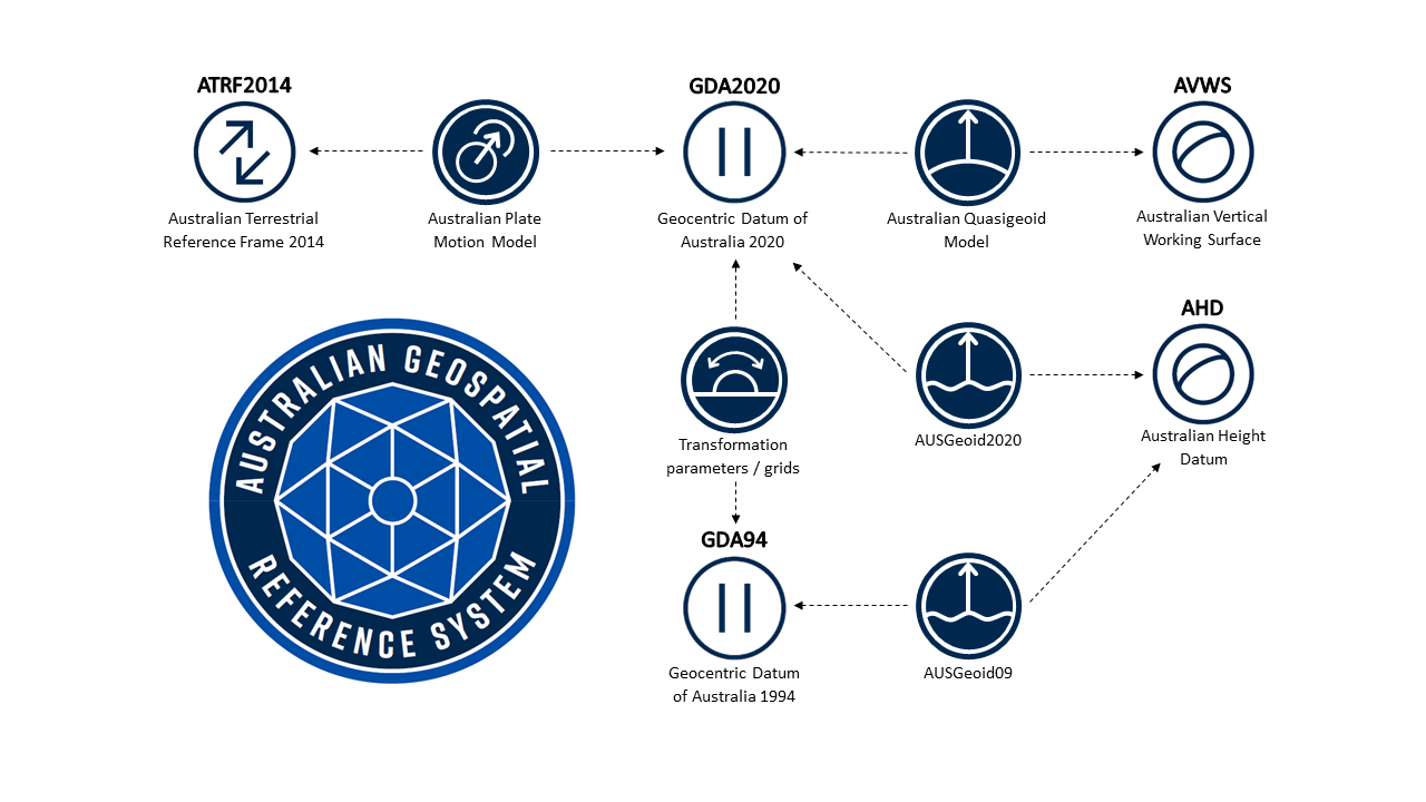
This diagram shows how users can move between the range of legacy Australian datums and the new datums released in the Upgrade to the Australian Geospatial Reference System.
GDA94 and GDA2020 (Static Datums)
- GDA2020 is a static datum – just like GDA94
- A ‘static’ datum means that the coordinates of features (e.g. roads, buildings and property boundaries), do not change with time
- GDA94 - coordinates of features are based on the position of the Australian plate in 1994
- GDA2020 - coordinates of features are based on the position of the Australian plate in 2020 (~1.8 m northeast of GDA94).
- The upgrade to GDA2020 is to ensure spatial data can be more closely aligned to positions observed using Global Navigation Satellite Systems (e.g. GPS)
- GDA2020 is available for use now
- Users can transform between GDA94 and GDA2020 using transformation parameters or grids.
Australian Terrestrial Reference Frame 2014
- The Australian Terrestrial Reference Frame 2014 (ATRF2014) is a time dependent reference frame aligned to the International Terrestrial Reference Frame 2014 (ITRF2014)
- A ‘time-dependent reference frame / earth fixed’ means that positions of features change with time due to plate tectonic motion
- GPS operates in a time-dependent reference frame.
- ATRF2014 coordinates change with time as the Australian plate moves 7 cm/yr north eastwards
- A user can choose to use either GDA2020 or ATRF2014 depending on their requirements.
- Users of ATRF2014 are expected to be predominantly from the Intelligent Transport Services (e.g. autonomous vehicles) and Location Based Services (e.g. mobile applications).
- ATRF2014 is available for use now.
Australian Vertical Working Surface
- GNSS provides you with position, including a height. This height is called an ‘ellipsoidal’ height (see figure below)
- The ellipsoid (a slightly squashed sphere) is a simple representation of the Earth.
- Water flows in accordance with gravity, not according to the ellipsoid. For this reason, the ellipsoid is not an appropriate reference surface for height applications
- The Australian Height Datum (AHD) was developed in the 1960’s and 1970’s and is the first and only national height reference surface. It is roughly equivalent to the mean sea level of the ocean around Australia in the late 1960s at 32 tide gauges.
- AHD has a number of biases and distortions which make it unsuitable for some users
- The AUSGeoid model provides a way to convert ellipsoid heights to Australian Height Datum (AHD) heights but is only accurate to 6-13 cm
- The Australian Vertical Working Surface (AVWS) is a new reference surface for heights in Australia free of the bias and distortion in AHD
- AVWS heights can be computed directly from GNSS with accuracy of 4-8 cm
- AVWS is available for use now