
The first official national Australian geodetic datum was actually called the Australian Geodetic Datum (AGD). It was proclaimed in the Australian Commonwealth Gazette No. 84 of 6 October 1966. The proclamation included the parameters of the local ellipsoid, known as the Australian National Spheroid (ANS), which defines the adopted size and shape of the earth, and the position of the origin point: Johnston Geodetic Station. The accompanying national map projection, a transverse Mercator projection that conforms to the internationally accepted Universal Transverse Mercator Grid system, was called the Australian Map Grid (AMG).
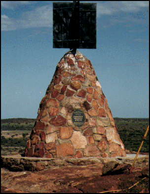
Johnston Geodetic Station
Stone marker
| JOHNSTON: | |
|---|---|
| Latitude | S 25° 56' 54.551 5" |
| Longitude | E 133° 12' 30.0771" |
| Ellipsoidal height | 571.2 metres |
| Australian National Spheroid: | |
| Semi-major axis (a) | 6,378,160.0 metres |
| Semi-minor axis (b) | 6,356,774.719 metres |
| Flattening (f) | 1/298.25 |
AGD coordinates were propagated throughout Australia from the 1966 national adjustment. There continued to be national re-adjustments of the AGD in subsequent years as new observations were introduced. Recognising the need for Australia to eventually move to a geocentric datum in October 1984, the National Mapping Council resolved to adopt the 1982 adjustment as a first step in that process. To distinguish between the two versions of the Australian Geodetic Datum, the different coordinate sets were referred to as AGD66/AMG 66 and AGD84/AMG84.
The final decision on adoption of the new adjustment was left to individual jurisdictions and only Queensland, South Australia and Western Australia adopted AGD84 with the other states and territories choosing to remain on AGD66.
The AGD provided a reference system that best fit the shape of the earth in the Australian Region but its origin did not coincide with the centre of mass of the earth. National datums were commonly non-geocentric before satellite based navigation systems were established in the early 1970’s
The distance between the origin points of GDA94 and AGD is approximately 200 metres. When the coordinates of a point on the Earth’s surface are converted from AGD to GDA94 this translates to a coordinate difference of approximately the same amount. The difference varies slightly depending on where you are in Australia.
The Geocentric Datum of Australia 2020 Technical Manual contains a detailed description of the difference between AGD66 and AGD84, along with detailed information on the main methods used to transform a coordinate between AGD66 ⁄ AGD84 and GDA94. It will fulfil the information requirements of the majority of users. The Geocentric Datum of Australia 1994 Technical Manual v2.4 includes details about other less accurate transformations that were used and may be required for legacy dataset operations.
For those historically minded, the technical details of the AGD and the Australian Map Grid (AMG) were originally described in Special Publication 7, The Australian Map Grid Technical Manual first published in 1968 by the National Mapping Council of Australia. This document and subsequent editions was superseded by the National Mapping Council of Australia’s Special Publication 10, The Australian Geodetic Datum Technical Manual (1986).
More about the Geocentric Datum of Australia
- What is GDA2020?
- Datum modernisation in Australia
- Geocentric Datum of Australia 1994
- Australian Geodetic Datum Geoscience Australia website
- Australian National Grid used prior to 1966 Geoscience Australia website
- Division of National Mapping Technical Reports