The Australian Government has committed $225m to provide 10 cm (or better) accurate positioning to anyone, anytime, anywhere in Australia in the near future. This is a significant improvement from the 5-10 m accuracy you can currently achieve using GPS enabled devices.
In anticipation for the growing use and reliance on positioning technology, the Permanent Committee on Geodesy is leading the upgrade of a number of elements of Australia’s Geospatial Reference System including, the introduction of the Australian Vertical Working Surface.
Key points:
- The Australian Vertical Working Surface (AVWS) is a new reference surface for heights in Australia
- The Australian Gravimetric Quasigeoid (AGQG) model is a gravity model that provides the offset between the ellipsoid and geoid
- The AUSGeoid model provides the offset between the ellipsoid and Australian Height Datum (AHD)
- A height user requirements study found the Australian Height Datum (AHD) and AUSGeoid are not capable of meeting some user requirements
- AVWS heights can be computed directly from GNSS without needing to connect to survey mark infrastructure with accuracy of 4-8 cm
- AHD will remain as the only legal height datum
- AVWS is available for use now
The Australian Height Datum is known to have a number of biases and distortions which mean GNSS users are only capable of deriving AHD heights with accuracy of 6-13 cm across Australia. Uncertainty in the national height datum of this magnitude makes AHD inappropriate for some applications that require a more accurate reference surface. In response to this Geoscience Australia led a user requirements study with FrontierSI to investigate current and future requirements for physical heighting in Australia.
The results of the study indicated that AHD is still fit for purpose for tasks over short distances (less than about 10 km) for projects such as cadastral, civil engineering, construction and mining while users are less satisfied when working over larger areas (greater than about 10 km) for environmental studies (e.g. flood, storm modelling), LiDAR surveys, geodesy, hydrography.
A recommendation of the study was to therefore adopt a “two-frame” approach similar to that done with GDA2020 and ATRF. AHD will remain as the national height datum and the Australian Vertical Working Surface (AVWS) will be made publicly available on 1 January 2020 for those who need it.
The Australian Gravimetric Quasigeoid (AGQG) model is a model of the Australian gravity field and like the AUSGeoid model which is used to derive AHD heights, the AGQG model ζAGQG can be used to compute AVWS heights HAVWS.
Global Navigation Satellite System (GNSS) ellipsoidal heights (h) can be converted to AVWS heights by subtracting the height anomaly (ζ) provided by the AGQG model. This is advantageous since GNSS ellipsoidal heights are relatively cheap and easy to obtain in comparison to large-scale levelling campaigns. Derived AVWS heights (HAVWS) can be determined by subtracting the AGQG model values (ζAGQG) from GNSS ellipsoidal height observations.
HAVWS= h - ζAGQG
The difference between AHD and AVWS is a combination of bias and distortion due to:
- The ocean’s time-mean dynamic topography (MDT) and the short tide gauge observation periods, the zero reference of the AHD (MSL at 32 mainland tide gauges) is not coincident with an equipotential surface (e.g. the geoid). The differences largely manifest in a north-south tilt of ~0.7 m in the AHD relative to the geoid across the continent. This tilt can be eliminated by the use of MDT models at tide gauges to correct for the offset between the sea surface recorded at the tide gauges and the geoid.
- The levelling derived heights contain local and regional distortions due to systematic and gross errors in the Australian National Levelling Network (ANLN) that propagated through the national network adjustments completed in 1971.
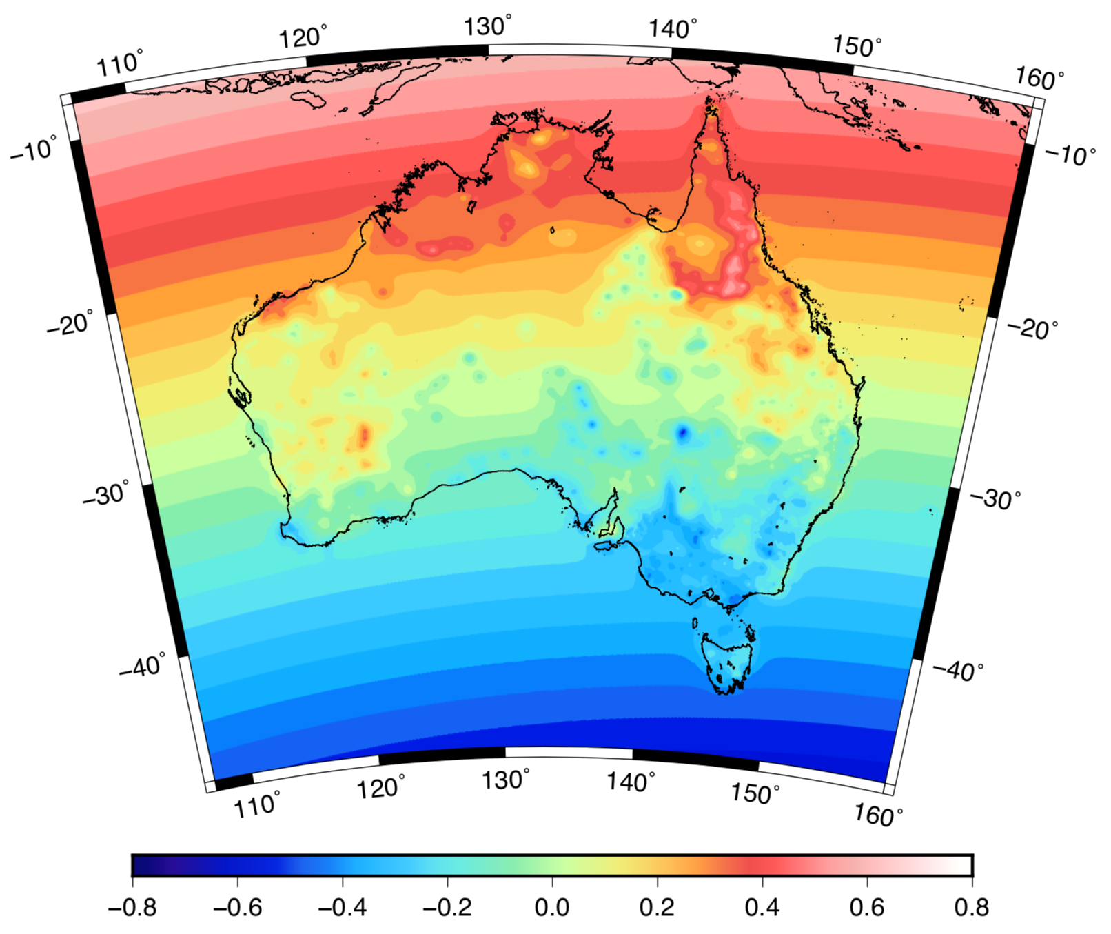
The biases and distortions associated with AHD mean GNSS users are only capable of deriving AHD heights from AUSGeoid2020 with accuracy of 6-13 cm across Australia. The accuracy of AGQG is between 4-8 cm across Australia.
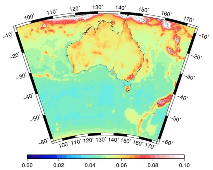
This addresses one of the biggest concerns from the users who have noticed the quality of their data (e.g. LiDAR) was starting to become more accurate than the datum (AHD) when they applied AUSGeoid. Geoscience Australia will be working with all the states and territories to continuously improve AGQG as new gravity data is included and modelling techniques are refined.
For more detailed information, please refer to the Australian Vertical Working Surface Technical Implementation Plan.