
ICSM ePlan Operation
The ICSM ePlan Protocol set of documents was finalised and ratified by the ICSM at its Perth meeting in November 2010. These documents have been circulated to Surveying Software Vendors and the surveying industry for inclusion into their software packages.
Jurisdictional protocols and schemas have been published in New South Wales, Victoria, South Australia and Queensland to provide the Software Vendors with appropriate enumerations and business rules.
New South Wales have developed a portal through which ePlan Files (CIF) can be validated against the ePlan Protocol.
Queensland is Beta Testing Web Services to access digital data and web based validation services which will be available to the Software vendors in early 2011.
Victoria is in the process of developing detailed user requirements or internal processing of the digital files.
South Australia has developed their enumeration schemas and local protocol documents.
The working group is currently working with four software vendors at a national and Jurisdictional level.
Role of ePlan
The ePlan working group is focussed on introducing a digital protocol for the transfer of cadastral data between the Surveying Industry and Government. This group has been charged with the following responsibilities:
- Investigate the methods to create, validate and visualise digital cadastral data to streamline the processing and distribution of Cadastral Survey Data.
- Engage the surveying industry to integrate ePlan into existing work practices using industry standard software produced by survey package vendors.
The working group is made up of technical experts from the eight states and territories of Australia and New Zealand working in the management of cadastral data.
1.1 ePlan Development Phase
At the November 2003 ICSM meeting, it was agreed that a new Working Group be created to review the options for the development and implementation for electronic lodgement and transfer of survey information. The primary goal of this work was to maximise efficiencies inherent in electronic systems and minimise the inefficiencies and costs of using paper for survey records. The ePlan Working Group was subsequently formed in early 2004. At this time the ePlan Working Group Terms of Reference were established, to:
- Implement a communication strategy involving industry stakeholders
- Produce a generic UML (Unified Modelling Language) model
- Develop or identify standard UML tools for data capture, visualisation and validation
- Develop an XML schema for cadastral survey, infrastructure and survey control objects
- Develop a high level business case for adoption of ePlan standards
- Make recommendations for implementation, review and management of ePlan standards
- Provide advice to ICSM on other areas of electronic survey data transfer
- Provide a work plan and regular reports to ICSM on progress
It was further agreed that the Electronic Access for Registry Lodgement (EARL) project team in the Queensland Department of Natural Resources and Water (now the Department of Environment and Resource Management) was best placed to undertake the majority of the initial work.
By June 2007 an operational model was installed and in use in northern Queensland offices of the Department of Natural Resources and Water. The system uses LandXML as a data transfer standard to capture, validate and visualise cadastral survey data.
1.2 ePlan Implementation Phase
As a result of the achievements in the development phase, the Working Group has moved to the implementation phase; although development and enhancement is ongoing.
The Terms of Reference for the implementation phase are:
- Trialling and adapting the data transfer standard and business objects through implementation in at least two jurisdictions such that:
- Surveyors can complete online cadastral infrastructure searches of jurisdictional databases and receive standard LandXML survey data downloads
- Create a cadastral survey (data) plan using proprietary vendor applications that is suitable for lodgement with the relevant jurisdictional authorities
- Have visualised, validated and approved by the relevant jurisdictional authorities as a spatially and legally valid instrument for land title registration
- Development, publication and maintenance of reference implementation documents, models, standards and business object tools to assist industry implementation
- Provide advice on any other issues/areas where ICSM may be able to provide national leadership in the electronic transfer of land surveying data
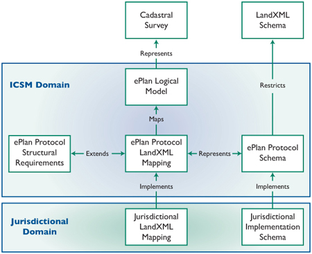
2 ePlan Protocol Documentation and Schema Files
The ICSM ePlan Protocol specifications consist of a suite of documents and XML schema files which are available for download from the Downloads page. These include:
- The Logical Model that maps survey plans into a logical data structure
- The LandXML Mapping that maps the logical model to the physical file format (LandXML)
- The Structural Requirements that defines complex representations of data in LandXML
- The Schema Architecture that defines the relationships between the various XML files that comprise the Protocol.
- The LandXML schema (available from landxml.org)
- The suite of ePlan XML Schema files; a subset of the LandXML schema specifically for ePlan
The following Diagram shows the relationship between these components:
 These documents were developed in conjunction with the ePlan Working Group, Software Vendors and the Surveying Industry.
A governance framework for the ePlan documentation exists to ensure issues identified by stakeholders are managed in a timely and consistent manner.
To enable the publishing of jurisdictionally based documentation a web service has been set up on the Australian Government GovDex site to facilitate discovery and comment on the ePlan Protocol by Industry and Stakeholders. We encourage all users of digital cadastral survey data who wish to contribute to the protocol to register as users to this site. The site is accessed at https://govdex.gov.au/confluence/display/ICSMEWG.
![]()
The current version of ICSM ePlan (November 2016) can be accessed from these hyperlinks:
LandXML Schema
Model
Protocol
LandXML Mapping
LandXML Structural Requirements
Schema Architecture
Schema Files
- xml-gov-au-icsm-eplan-cif-administrative-area-2.0.xsd
- xml-gov-au-icsm-eplan-cif-annotations-2.0.xsd
- xml-gov-au-icsm-eplan-cif-enumerated-types-2.0.xsd
- xml-gov-au-icsm-eplan-cif-protocol-2.0.xsd
- xml-gov-au-icsm-eplan-cif-referencedata-2.0.xsd
- xml-gov-au-icsm-eplan-cif-survey-certificates-2.0.xsd