
Key points:
- People, phones and cars will soon be able to position themselves with accuracy of 10 cm (or better) anywhere, anytime in Australia
- The Australian Geospatial Reference System has elements which aren’t accurate to 10 cm
- The Australian Geospatial Reference System is currently limited in our ability to provide Findable, Accessible, Interoperable and Reusable (FAIR) data
- We need to upgrade the Australian Geospatial Reference System so people can get maximum benefit from precise positioning
The Australian Government has committed $225m to provide 10 cm (or better) accurate positioning to anyone, anytime, anywhere in Australia in the near future. This is a significant improvement from the 5-10 m accuracy you can currently achieve using GPS enabled devices.
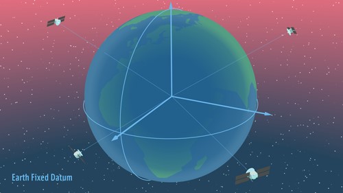
In anticipation for the growing use and reliance on positioning technology, the Geodesy Working Group is leading the upgrade of a number of elements of Australia’s Geospatial Reference System including the static datum, the introduction of a time dependent reference frame, improved geodetic infrastructure and standards development to improve access and efficiency of geodetic data.
Upgrade 1: Upgrading the static datum from GDA94 to GDA2020
Key points:
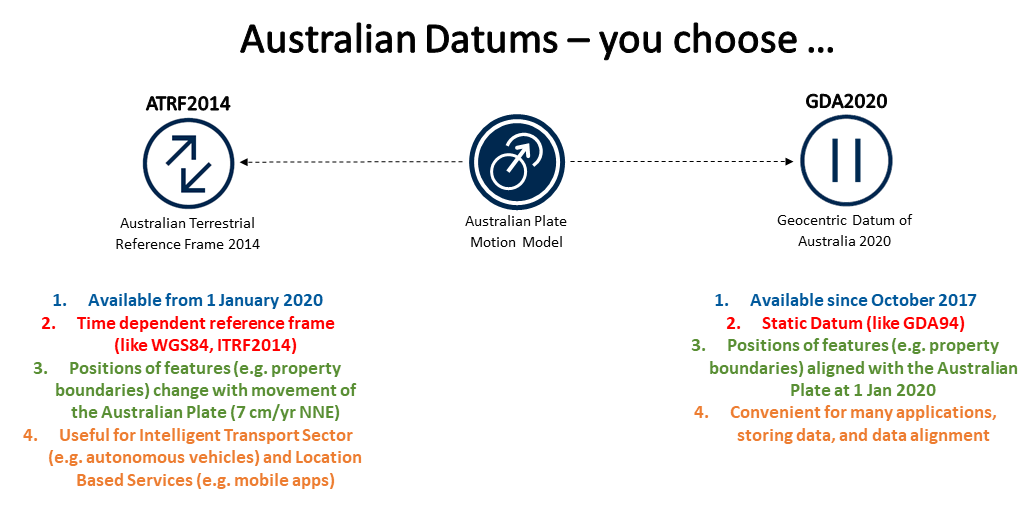
- GDA2020 is a static datum – just like GDA94
- A ‘static’ datum means that the coordinates of features (e.g. roads, buildings and property boundaries), do not change with time
- The upgrade to GDA2020 is to ensure spatial data can be more closely aligned to positions observed using Global Navigation Satellite Systems (e.g. GPS)
- GDA2020 is available for use now
In anticipation for the growing use and reliance on positioning technology, the Permanent Committee on Geodesy led the development of the upgrade of Australia’s ‘static / plate fixed’ datum from the Geocentric Datum of Australia 1994 (GDA94) to GDA2020 which was released in 2017. A ‘static’ datum means that the positions of features (e.g. roads, buildings and property boundaries), do not change over time despite the ongoing changes in the Earth’s surface (e.g. plate tectonic motion). This is beneficial for many applications where it is easier if the coordinates of features do not change (e.g. a major road development project).
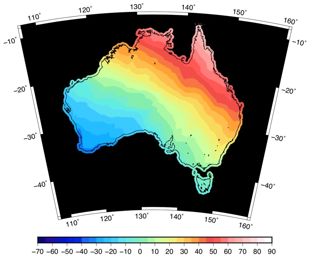
Historically, location differences of a metre or so have not been an issue, because GNSS has traditionally only provided accuracy of 5-10 m. In fact, when GDA94 was adopted in 2000, GPS positions were ‘accurate’ to 100 metres. Since then, however, two important things have happened: 1) Australia’s tectonic plate – the Earth’s fastest moving continental plate – has moved about 1.5 metres northeast (approximately 7 cm / yr), and 2) positioning technology has evolved considerably. By 2020, Australia will have moved 1.8 metres northeast of where it was in 1994, and many of us will own devices that pinpoint places as small as, well, a smartphone. With real-time access to precise satellite positioning at our fingertips, we’ll notice discrepancies with GDA94-mapped features. The upshot is that Australia’s datum needs updating so we can reap the benefits of 21st Century positioning technology.
Upgrade 2: Introduction of the Australian Terrestrial Reference Frame 2014
Key points:
- The Australian Terrestrial Reference Frame 2014 (ATRF2014) is a time dependent reference frame
- A ‘time-dependent reference frame / earth fixed’ means that positions of features change with time due to plate tectonic motion
- GPS operates in a time-dependent reference frame.
- ATRF2014 coordinates change with time as the Australian plate moves 7 cm/yr north eastwards
- A user can choose to use either GDA2020 or ATRF2014 depending on their requirements.
- Users of ATRF2014 are expected to be predominantly from the Intelligent Transport Services (e.g. autonomous vehicles) and Location Based Services (e.g. mobile applications).
- ATRF2014 is available for use now
Australian and International research shows, that there is a rapidly growing user community including Location Based Services (LBS) and Intelligent Transport Services (ITS) that need real-time, high-precision positioning solutions aligned to a global, time-dependent reference frame, such as the frames in which GNSS operate.
In recognition of emerging user needs for static and time-dependent reference frames, the Intergovernmental Committee on Surveying and Mapping (ICSM) and the Spatial Information Council (ANZLIC) have endorsed a 'two-frame' approach to support users who prefer to use a static datum, while also meeting the needs of those who require a reference frame that accommodates ongoing changes in the Earth.
In 2020, Australia will adopt the two-frame approach, enabling users to work with a static datum, GDA2020, or with a time-dependent reference frame known as the Australian Terrestrial Reference Frame (ATRF2014). Given the diverse range of user requirements in Australia, the choice of which reference frame to use (GDA2020 or ATRF2014) will remain with the user for the foreseeable future.
Upgrade 3: Introduction of the Australian Vertical Working Surface
Key points:
- GNSS provides you with position, including a height. This height is called an ‘ellipsoidal’ height (see figure below)
- The ellipsoid (a slightly squashed sphere) is a simple representation of the Earth.
- Water flows in accordance with gravity, not according to the ellipsoid. For this reason, the ellipsoid is not an appropriate reference surface for height applications
- The Australian Height Datum (AHD) was developed in the 1960’s and 1970’s and is the first and only national height reference surface. It is roughly equivalent to the mean sea level of the ocean around Australia in the late 1960s at 32 tide gauges.
- AHD has a number of biases and distortions which make it unsuitable for some users
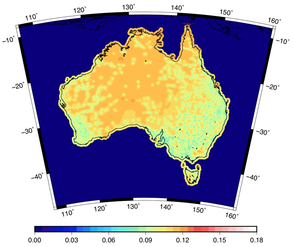
- The AUSGeoid model provides a way to convert ellipsoid heights to Australian Height Datum (AHD) heights but is only accurate to 6-13 cm
- The Australian Vertical Working Surface (AVWS) is a new reference surface for heights in Australia free of the bias and distortion in AHD
- AVWS heights can be computed directly from GNSS with accuracy of 4-8 cm
- AVWS will be available for use from 1 January 2020
For all the benefits of GDA2020 and ATRF2014, these upgrades only provide GNSS users with the ability to compute their position and align spatial data accurately with respect to the ellipsoid – a simplified mathematical representation of the Earth’s surface. However, many height applications require ‘physical heights’, that is, height referenced to a surface of ‘equal gravity potential’ (i.e. the geoid) where water will flow from higher heights to lower heights. This is not always the case with ellipsoidal heights. The difference between the ellipsoid and geoid is between -30 and +80 m across Australia.
For this reason we have a physical datum, known as the Australian Height Datum (AHD) which is closely aligned to the geoid and a model to convert ellipsoidal heights to AHD heights known as AUSGeoid.
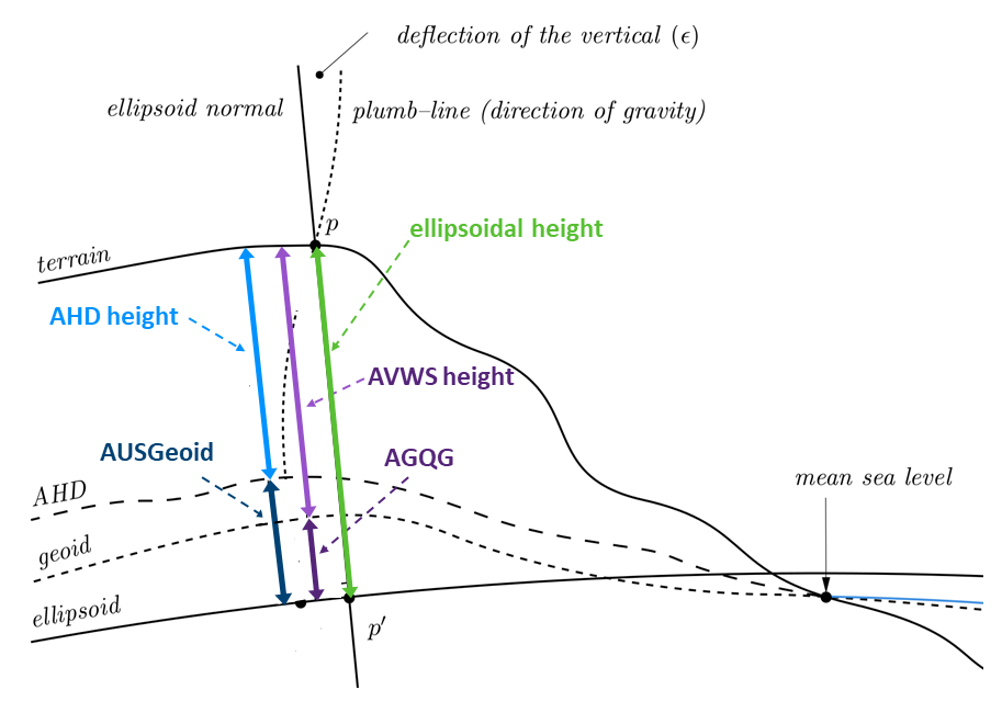
Nonetheless, AHD is known to have a number of biases and distortions which mean GNSS users are only capable of deriving AHD heights with accuracy of 6-13 cm across Australia. Uncertainty in the national height datum of this magnitude makes AHD inappropriate for some applications that require a more accurate reference surface. In response to this Geoscience Australia led a user requirements study with FrontierSI to investigate current and future requirements for physical heighting in Australia.
The results of the study indicated that AHD is still fit for purpose for tasks over short distances (less than about 10 km) for projects such as cadastral, civil engineering, construction and mining while users are less satisfied when working over larger areas (greater than about 10 km) for environmental studies (e.g. flood, storm modelling), LiDAR surveys, geodesy, hydrography.
A recommendation of the study was to therefore adopt a “two-frame” approach similar to that done with GDA2020 and ATRF2014. AHD will remain as the national height datum and the Australian Vertical Working Surface (AVWS) will be made publicly available on 1 January 2020 for those who need it.
The Australian Gravimetric Quasigeoid (AGQG) model is a model of the Australian gravity field and meets the key criteria identified in the user requirements study:
- cost-effective to develop and implement;
- nationally consistent;
- reliable and robust model to transform heights from GNSS ellipsoidal heights to physical heights with uncertainty over large regions (10s-100s km);
- compatible with GDA2020, GDA94, International Terrestrial Reference Frame (ITRF) realisations and Australian Terrestrial Reference Frame (ATRF2014);
- easily used to connect onshore and offshore heights.
Importantly, the accuracy of AGQG is between 4-8 cm across Australia. This addresses one of the biggest concerns from the user requirements study who have noticed the quality of their data (e.g. LiDAR) was starting to become more accurate than the datum (AHD). Geoscience Australia will be working with all the states and territories to continuously improve AGQG as new gravity data is included and modelling techniques are refined.
Who is leading the Upgrade of the Australian Geospatial Reference System?
The Intergovernmental Committee on Surveying and Mapping, the Permanent Committee on Geodesy and the GDA Modernisation Implementation Working Group are helping users and government agencies to build transitional tools and technical resources, and providing information for software developers, equipment providers and users of spatial information. For more information or assistance please Connect with Us.