One of the biggest challenges with hydrographic surveying is the relationship between the ellipsoid and chart datum in the coastal environment. With the continuing development of high-accuracy GNSS surveying methods including Precise Point Positioning (PPP) and second generation Satellite Based Augmentation Services (SBAS), the ability to measure the vertical component with the required accuracy and precision to facilitate high accuracy ellipsoidal surveys is now a reality. To allow for the reduction of this data to chart datum a new separation model is required to augment traditional tidal models. In Australia, this model will be the AUSHYDROID and is expected to support nearshore, coastal and offshore ellipsoidal surveying within the Australian region.
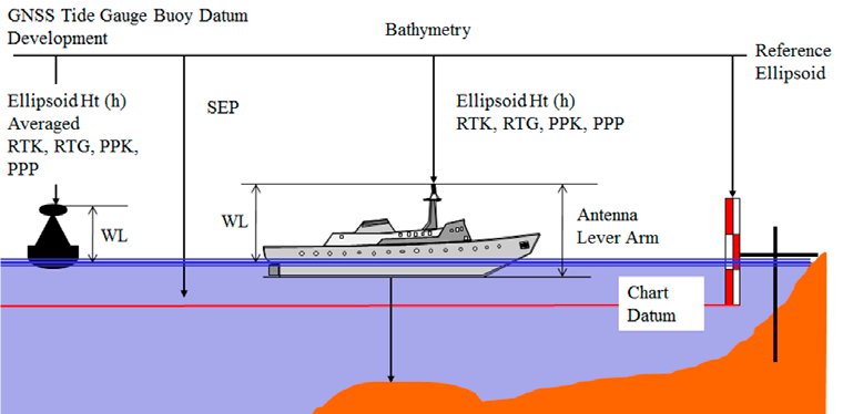
AUSHYDROID will allow hydrographic surveyors and other end users to transform geospatial data referenced within the International Terrestrial Reference Frame (ITRF) between tidal (Lowest Astronomical Tide (LAT)) and ellipsoidal (GRS80) vertical datums (see Figure 1). In addition to supporting surveying on the ellipsoid, AUSHDROID will also have a number of other benefits that will contribute to Australia’s blue economy including:
- Linking bathymetry and land based observations through a common reference frame;
- Enabling the definition of coastlines and inter-tidal zones on a national scale;
- Assist in defining maritime baselines, marine cadastres and claims of sovereignty; and
- Provide a baseline for sea-level rise estimates and climate change strategies for coastal infrastructure.
The AUSHYDROID Working Group has released a number of Use cases and welcomes comments and feedback:
Use Case - Coastal Sea Level Warnings
Use Case - Under Keel Clearance
ICSM instigated the AUSHYDROID Working Group to commence development of the business processes, use cases, minimum standards and specifications for data and the models to improve the determination of the vertical datum separation at a location. The inaugural meeting of this WG took place at the Australian Hydrographic Office on the 2 May 2019.
For more information on the AusHydroid Working Group contact Tides@defence.gov.au or icsm@ga.gov.au